
Written by Eric Wright, TNI stewardship director
Age is an interesting concept. We’ve all met a young child that introduces themselves by saying, “Hi, my name is Emma. I’m 4 years old.” Early on, we learn our age affects our life and how others interact with us. Age, in human years, is concrete, well-documented, and easy to comprehend. We may not remember our own entrance into this world, but our parents and birth certificate can verify how long we’ve been around. Geologically, age is far more complex. Luckily, geologists have developed methods to help us deduce how and when geologic processes occur.
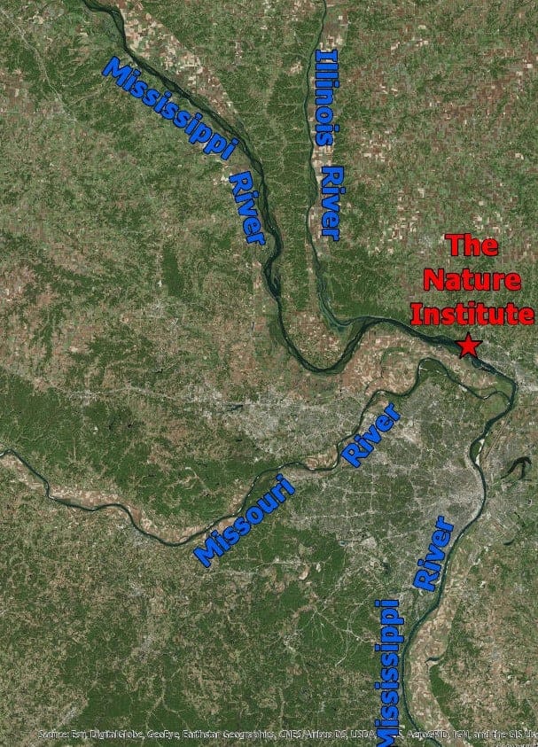
As I stared at the Mississippi River from atop our hill prairie at The Nature Institute (TNI), I asked myself, “How old is the Mississippi River?” I quickly realized that I was under-informed, and I don’t accept being under-informed. While searching for an answer, I traveled through time and discovered the remarkable events that have shaped and molded what lies beneath our nature preserves.
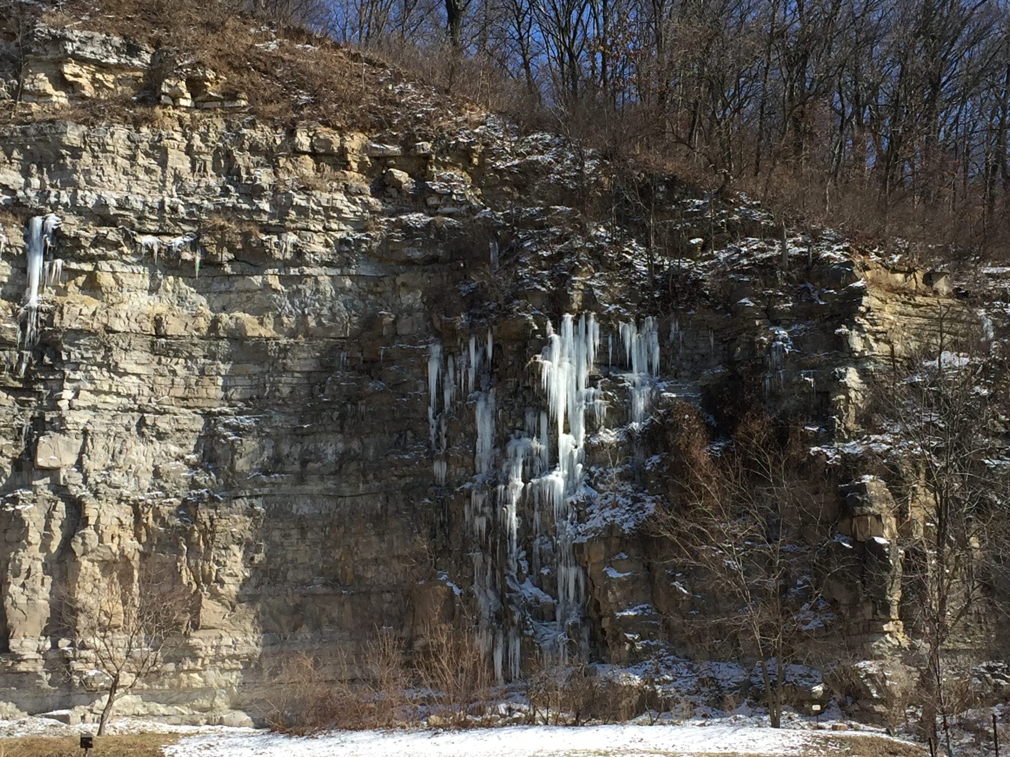
Bluff line where TNIs John M. Olin Nature Preserve stands, picture taken at Hoffman Gardens along the Great River Road, Route 100.
First, I want to throw out a qualifier. I am not a geologist by trade. I’ve utilized my resources to help create and fact check this blog post, but my interpretation may not be as thorough (or jargon laden) as the same story told by a professional geologist. The ability of geologists to reconstruct geologic history over a period of 4.6 billion years will always fascinate me. Please reference the sources at the end of this post for further reading.
We start our story about 1.4 billion years ago. During this time, also known as the Precambrian time, Illinois’ Precambrian basement was formed by the cooling of magma. Rock that is formed by the cooling of magma (underground lava) or by the cooling of lava is known as igneous rock. The Illinois Precambrian basement is composed primarily of granite and is located 2000 feet below the surface in northern Illinois and as deep as 17,000 feet below the surface in southern Illinois. Southern Illinois subsided (sank into the earth) over hundreds of millions of years.
Let’s skip ahead to 570 million years ago.
During the next several hundred millions of years, Illinois spent most of its time underwater. Sedimentary rock, rock formed by the deposition of sediments and organic matter with subsequent compaction, was formed during these years. The time period of particular interest to us is between 360 and 286 million years ago. During this time, Illinois was a shallow sea with a shifting coastline. Sediments and the remains of tiny shelled creatures dropped to the bottom of the inland sea and eventually formed Mississippian and Pennsylvanian limestones. These limestones can be seen as you gaze at the bluff faces along IL Route 100 (aka The River Road).
Beyond the beauty of our bluffs, the underlying limestone is also responsible for the sinkholes that occur throughout southwestern Illinois and on our properties. Rainfall absorbs carbon dioxide making water slightly acidic and capable of dissolving the minerals in limestone. Over time, the water carves out underground streams which form into caves. Sinkholes are formed when the caves beneath the surface collapse and/or subsequently pull rock and soil down into the caverns below.
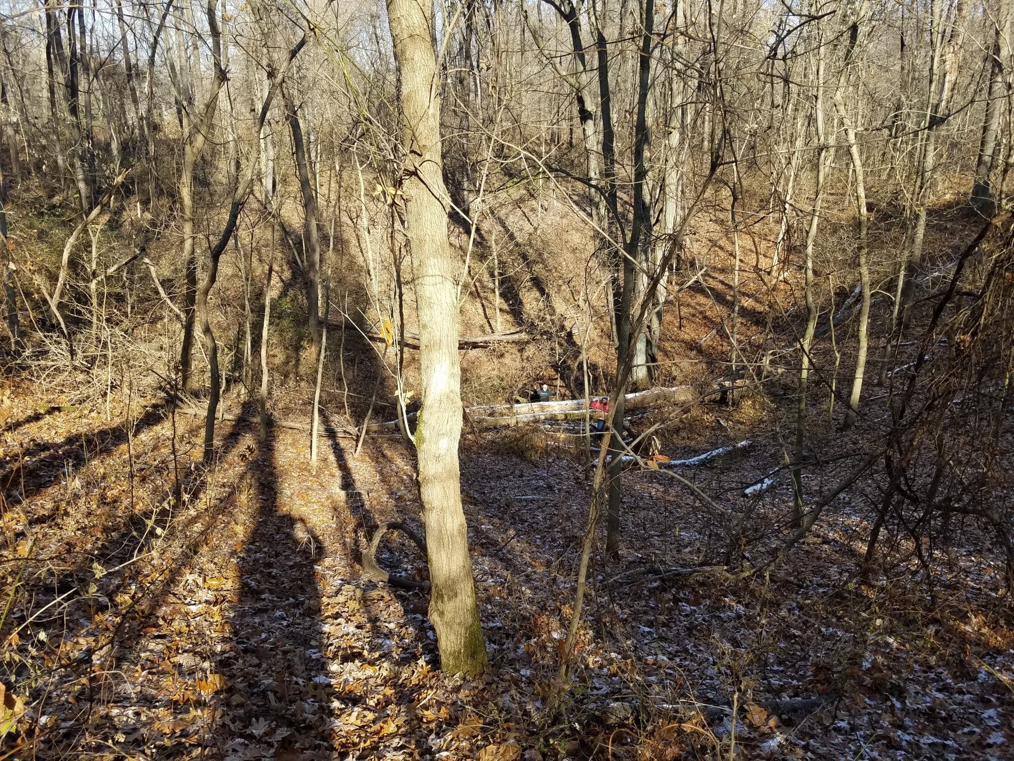
Sinkhole within TNI’s Mississippi Sanctuary trails
From 286 million years ago to current day, most of Illinois remained above sea level preventing the formation of new sedimentary rock. Although we lack fossil evidence, dinosaurs roamed across most of Illinois during the Mesozoic era (245 – 66 million years ago). Erosion and multiple glaciations erased any fossil evidence of the dinosaurs. The supercontinent Pangea broke apart during the Jurassic period (208 – 144 million years ago) and the continents slowly settled into their current positions.
Now that the background has been covered, we can start talking about the age of the Mississippi River. I asked a few other biologists and even called a couple local museums in my search for answers. I received differing answers with marginal confidence. So, I dove deep into internet resources and borrowed several books from my local library. Still, I did not found a definitive answer. I decided that I must use my favorite multiple choice test strategy, the process of elimination.
Let’s travel back in time again to 286 million years ago…
when the last sedimentary rock layer was formed in Illinois. Outside of some technicalities, we can say that the Mississippi River was not formed while Illinois was under water.
Skip ahead to the Jurassic period when Pangea was being torn apart by plate tectonics: it’s hard to imagine the Mississippi River maintained its course through volcanic eruptions, earthquakes, and shifting continents. In western North America, The Rocky Mountains were being thrust upward as late as 40 million years ago. Let’s make another assumption and assume that a mountain building event would move and reshape river systems across the entire continent. Therefore, the Mississippi River is less than 40 million years old.
Now, we are going to approach the question from the other direction. During the Illinoisan and Wisconsinan glaciations (300,000 to 10,000 years ago), glacial till and moraines created dams that rerouted the Mississippi River to the west. The former Mississippi River valley was later claimed by the Illinois River as the glaciers retreated. Unfortunately, this change in channel occurred upstream of us and therefore doesn’t help answer our question.
Between 5.3 and 2.4 million years ago, a major river system flowed from east to west across Illinois, through Missouri into Kansas, then south to the Gulf of Mexico. I’m going to assume (again) this ancient river flowed through the Mohomet River valley in central Illinois down the Illinois River valley to near St. Louis where it followed the Missouri River valley to Kansas City. At some point during this time period, the Mississippi was diverted near St. Louis to its current channel. Because of our location on this ancient river path, I will error on the side of caution and say the Mississippi River is at least 5.6 million years old.
To answer the question in the title of this blog post, the Mississippi River below the bluffs at TNI is between 5.6 and 40 million years old. Thirty-four million years may seem like a large window, but in the context of the 1.4 billion year window since the formation of the Precambrian basement, we have eliminated over 97% of the geologic time scale. Also, we discovered that the river below our bluffs at TNI could be one of the oldest stretches of the modern Mississippi River.
There wasn’t an easy answer to this seemingly simple question, but as I’ve heard before, “it’s more about the journey than the destination”.
References:
Wiggers, Ray. Geology underfoot in Illinois. Mountain Press Publishing, 1997.
https://isgs.illinois.edu/outreach/geology-resources/build-illinois-last-500-million-years
Thanks, very cool from another amateur fan of geology.
In 1970, for a Graduate level Geology course, I went on a field trip to what was called the Mississippi River Valley. It was about 20 miles North East of Ottawa, IL…..In other words, it almost made it to where Chicago is, before curving back towards Saint Louis. (Of course, there was no Lake Michigan, at the time)
I’m not sure where it was in Wisconsin, before the Ice dams moved it to it’s current position.
That was fascinating. Learning about the formation of limestone, caves and sinkholes was an added bonus for me. Thanks so much for researching and publishing this. I woke up this morning and for some unknown reason, I wanted to know the age of The Mississippi River. This article was delightful!
It was always to my understanding that Illinois, especially So. Illinois never had any dinosaurs & one of the reasons I was told was no fossils ever found—I did not know glaciers had removed them all, so it makes sense now…… it is great to learn from you that indeed, we had some dino’s after all.
This was extremely well written. Fascinating! Thank you for your work.